


Larkin Twp. Voting District, Nobles County, Minnesota
About
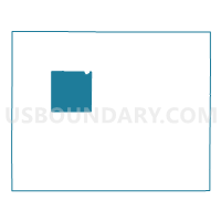
Outline

Summary
| Unique Area Identifier | 603345 |
| Name | Larkin Twp. Voting District |
| County | Nobles County |
| State | Minnesota |
| Area (square miles) | 35.80 |
| Land Area (square miles) | 35.75 |
| Water Area (square miles) | 0.06 |
| % of Land Area | 99.85 |
| % of Water Area | 0.15 |
| Latitude of the Internal Point | 43.71610540 |
| Longtitude of the Internal Point | -95.87719400 |
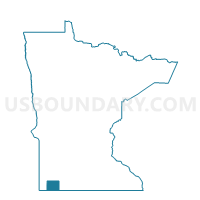
Maps

Graphs
Select a template below for downloading or customizing gragh for Larkin Twp. Voting District, Nobles County, Minnesota


Neighbors
Neighoring Voting District (by Name) Neighboring Voting District on the Map
- Bloom Twp. Voting District, Nobles County, MN
- Dewald Twp. Voting District, Nobles County, MN
- Leota Twp. Voting District, Nobles County, MN
- Lismore Twp. Voting District, Nobles County, MN
- Olney Twp. Voting District, Nobles County, MN
- Summit Lake Twp. Voting District, Nobles County, MN
- Westside Twp. Voting District, Nobles County, MN
- Wilmont Voting District, Nobles County, MN
- Wilmont Twp. Voting District, Nobles County, MN
Top 10 Neighboring County Subdivision (by Population) Neighboring County Subdivision on the Map
- Leota township, Nobles County, MN (390)
- Wilmont city, Nobles County, MN (339)
- Summit Lake township, Nobles County, MN (323)
- Dewald township, Nobles County, MN (254)
- Westside township, Nobles County, MN (218)
- Olney township, Nobles County, MN (205)
- Larkin township, Nobles County, MN (188)
- Wilmont township, Nobles County, MN (184)
- Lismore township, Nobles County, MN (175)
- Bloom township, Nobles County, MN (158)